A web application designed for urban landscape analysis provides an innovative digital tool to study and visualize the qualities of the cityscape. This platform processes visual and spatial data of urban environments and transforms them into structured information that can be represented through charts, diagrams, and interactive dashboards. The purpose is to bridge the gap between subjective perception of urban space and objective, measurable data.
By integrating techniques such as image recognition, spatial mapping, and data visualization, the application captures the essence of the urban landscape, including architectural forms, building facades, open spaces, and patterns of human activity. The system allows users to upload or access urban images and spatial datasets, which are then analyzed to identify key elements and relationships within the cityscape.
The generated outputs, presented in the form of graphs and charts, enable urban designers, planners, and researchers to better understand visual coherence, spatial hierarchy, and social interactions in the built environment. Additionally, the application supports comparative analysis, scenario modeling, and evidence-based decision-making.
Ultimately, this digital tool enhances urban design practice by providing clear, data-driven insights into the complex structure of cityscapes, making planning processes more transparent, collaborative, and responsive to human experiences.
Continue…
The strength of such a web application lies in its ability to convert qualitative aspects of urban landscapes into quantitative datasets. Through advanced algorithms, it can evaluate visibility, spatial connectivity, density, and façade diversity, offering objective metrics that traditionally relied on subjective observation. Moreover, it enables real-time interaction, allowing users to filter, compare, and export analytical results for further studies. By integrating urban theory with computational analysis, the platform fosters a deeper understanding of how physical environments shape human behavior and perception. This makes it an essential resource for sustainable urban planning and evidence-based policy development.
About
This application represents the initial version of a section of a Master’s thesis in Urban Design at the Islamic Art University of Tabriz. The full title of the thesis is “Design and Proposition of Building Facade Patterns in Khavaran Town, Tabriz, with the Aim of Enhancing the Urban Landscape through a 3D Isovist Approach.” The final defense of this research was successfully held in September 2022 at the Architect Ali Tabrizi Hall, Faculty of Architecture and Urban Planning, Islamic Art University of Tabriz. Following the successful implementation of the Javaneh Grant program in March 2021, this research was officially supported by the Ministry of Science, Research and Technology of Iran and the Science and Technology Park of East Azerbaijan Province. The thesis was authored by Amin Shahamipour, with Prof. Morteza Mirgholami as the first supervisor, Dr. Mohammadtaghi Pirbabaei as the second supervisor, and Dr. Yaser Shahbazi as the advisor.
The attached document titled “Javaneh Plan – Notice of Acceptance and Allocation of Core Funding” represents an official letter of grant approval issued to Mr. Amin Shahamipour for his research project entitled “Designing and Determining Urban Block Patterns Using the 3D Isovist Approach.” This grant is formally approved and supported under project code 05-99-01-000216, reflecting a national-level endorsement of an innovative and research-based urban design system in Iran.
1. Overview of the Javaneh Plan
The “Javaneh Plan” is a governmental initiative designed to support creative and research-oriented projects proposed by young scientists, innovators, and designers. The aim is to encourage technological and scientific innovation by providing financial and institutional support for research that holds practical, developmental, and economic value. This program emphasizes applied research capable of transforming theoretical concepts into functional systems or products with measurable social and urban impact.
The project proposed by Amin Shahamipour—based on the Isovist 3D analytical method—was selected after academic review and evaluation by the Park of Science and Technology of East Azerbaijan Province. The letter confirms that his project has passed the initial stages of review and that financial and infrastructural support has been allocated for its completion.
2. Project Focus
The research titled “Designing and Determining Urban Block Patterns Using the 3D Isovist Approach” addresses spatial visibility, urban morphology, and perception of the built environment through computational modeling. The concept of the “Isovist” refers to the volume of visible space from a specific observation point within an urban or architectural setting. This approach, when extended to 3D simulations, provides valuable data on how citizens perceive, navigate, and interact with urban forms.
Through this project, the platform isovist.ir was conceptualized and later developed as a digital system to model, analyze, and visualize urban spaces in three dimensions. The website serves as both a research tool and an educational platform, integrating data visualization, spatial analytics, and urban design evaluation.
3. Funding Organizations and Their Roles
The grant document specifies three distinct entities that financially and institutionally support the project:
The Ministry of Science, Research, and Technology of Iran – This ministry provides the central governmental approval and oversight for the “Javaneh Plan.” Its role includes evaluating the scientific merit of the project, issuing official confirmation letters, and providing a share of the funding known as “support from the Ministry.” This confirms that the project is recognized at the national academic level.
The East Azerbaijan Science and Technology Park (EASTP) – The Park acts as both the local administrative and financial executor of the plan. It oversees project management, supervision, and the practical implementation of the funding. The Park provides laboratory access, innovation facilities, and consulting support to ensure that the project develops into a working technological system. It also monitors milestones to guarantee scientific and economic outcomes.
The Project Executor’s Share (Private Contribution) – According to the funding structure, the applicant (Mr. Shahamipour) is responsible for a matching contribution equal to the amount funded by the Park and the Ministry. This self-contribution reflects both a commitment to the research and the presence of pre-existing infrastructure, such as the isovist.ir platform and relevant software tools. This balance between institutional and private investment creates a sustainable model for applied research.
4. Funding Distribution
The financial section of the document outlines the approved and allocated funding in three major phases:
Capacity Building: 10,000,000 Rials
Research and Development : 50,000,000 Rials
Human Resources : 30,000,000 Rials
The total allocated credit equals 90,000,000 Rials, divided equally among the three supporters — the applicant, the Science Park, and the Ministry of Science. This ensures both financial balance and shared responsibility among all stakeholders.
The letter also mentions that the allocation of funds will occur after the completion of specific phases, and the funds will be disbursed in accordance with the project’s progress reports and technical documentation. This staged process helps ensure accountability and continuous evaluation of project performance.
5. Research Implementation Conditions
The funding approval is contingent upon compliance with the official Execution Agreement signed between the researcher and the Science and Technology Park. The agreement mandates that the applicant must use the allocated funds solely for research purposes such as software development, modeling, publication, and project dissemination. It also specifies that project progress will be monitored by the Park’s expert committee, and that reports must be submitted for each development stage.
Additionally, a percentage (typically 10%) of the total fund is reserved for final evaluation and approval upon project completion. This encourages successful delivery and quality assurance before full payment is released.
6. Significance of the Support
This grant approval serves as a formal acknowledgment of the scientific and technological value of the isovist.ir project. Receiving such support from the Ministry of Science and the East Azerbaijan Science and Technology Park positions the project as a legitimate research initiative within Iran’s national innovation framework.
It highlights the project’s potential in bridging the gap between academic research and real-world urban design applications. By employing 3D visualization, geometric computation, and spatial analytics, the system aligns with modern trends in smart urbanism, spatial cognition, and environmental psychology.
7. Institutional Collaboration
The collaboration between governmental bodies (the Ministry), semi-academic innovation centers (Science and Technology Park), and individual researchers (Mr. Shahamipour) demonstrates a hybrid model of national innovation support. This synergy allows local research to gain technical, administrative, and financial assistance while remaining academically independent.
The Park’s president, Dr. Alireza Vatankhah Her, has officially signed the document, confirming the Park’s commitment to managing the funds, monitoring the research progress, and facilitating project execution.
8. Relevance to the isovist.ir Platform
The isovist.ir system—originating from Shahamipour’s master’s thesis—embodies the outcomes expected from this grant. It uses the 3D Isovist analytical approach to evaluate visual perception in urban blocks and simulate the relationship between form, space, and visibility. The project transforms theoretical urban design knowledge into a computational framework that supports both academic research and professional practice.
The system can be applied in various contexts, such as:
Urban morphology and visibility studies
Cityscape enhancement through 3D simulation
Environmental behavior analysis
Integration of visual and spatial data for sustainable urban design
By connecting theoretical models with practical visualization, isovist.ir becomes a pioneering digital platform that contributes to the modernization of Iran’s urban design education and professional practice.
9. Broader Impact
Beyond the local scope, the grant enables the system’s scalability toward international collaboration. It creates a foundation for cooperation with European research institutes and universities, aligning with global methodologies in urban informatics, computational design, and digital twin technologies.
Moreover, the project’s interdisciplinary nature—bridging urban design, computer graphics, and spatial analytics—makes it adaptable to both academic studies and smart city management systems.
10. Conclusion
The attached grant document serves not only as an administrative confirmation of funding but also as a symbol of institutional trust and scientific validation. It marks a significant milestone in the evolution of isovist.ir from a thesis-based concept into an applied technological system supported by the Iranian innovation network.
Through the cooperation of the Ministry of Science, Research, and Technology, the East Azerbaijan Science and Technology Park, and Amin Shahamipour’s individual contribution, the project has received the resources and recognition necessary for expansion, research continuity, and potential commercialization at both national and international levels.
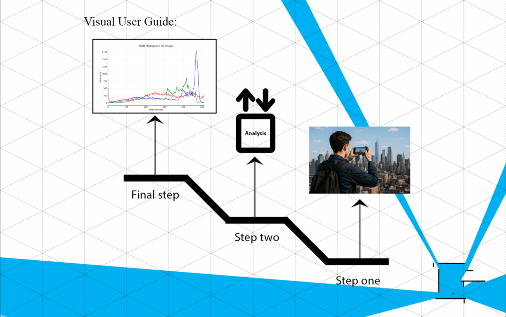
User Guide
Since the foundation of this application is based on the optical device (viewer) used by observers in urban environments, it requires its own specialized hardware. After installing the camera-equipped glasses and walking through urban spaces, the captured images should be uploaded to the application. Based on analyses of color in the urban landscape, the system will generate a color histogram as output.
The histogram charts are provided in two formats: PNG and PDF, which can be used for further analysis.
The main objective of this application is to record the color histograms of urban landscapes where observers experience a pleasant sense of place.